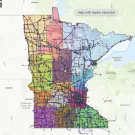
If Minnesota’s utility service areas were a jigsaw puzzle, it would take a long time to complete!
This was one of the thoughts that led to the Rural Renewable Energy Alliance (RREAL), the Clean Energy Resource Teams (CERTS), and the Center for Urban and Rural Affairs (CURA) at the University of Minnesota to co-create the Totally Awesome Map for Renewable Energy Collaboration.
The map, which was made possible by the generous support of the Regional Sustainable Development Partnerships, shows regions and county lines, electrical substations, electric lines, MnDOT facilities, Native Nation boundaries, and more.
To create this map, RREAL, CERTS, and CURA were able to obtain the services of the equally awesome Michael Karavolias to do the project. For Mike, this project provided an opportunity to use his problem solving skills while digging into energy policy and helping to solve energy inequities.